Heritage Walking Tour Booklet June 1984 by the Dover Heritage Group, Dover, NH, c. 1984.
In 1978, a group called Dover Tomorrow formed to promote the growth and prosperity of Dover. A subcommittee was tasked with promoting “appreciation of Dover’s heritage”. The Lively City Committee created the first Heritage Walk the next year. It was so popular that new tours were created every year, and held through 2007. By 1982, Dover’s historical society, the Northam Colonists, had taken over the research and creation of the Heritage Walking Tour Booklets. The information on the page below is a transcription of the original Heritage Walking Tour Booklet. The Library has a complete set of the Heritage Walking Tours if you would like to see the original booklets.
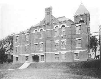
Dover High School, Chestnut Street
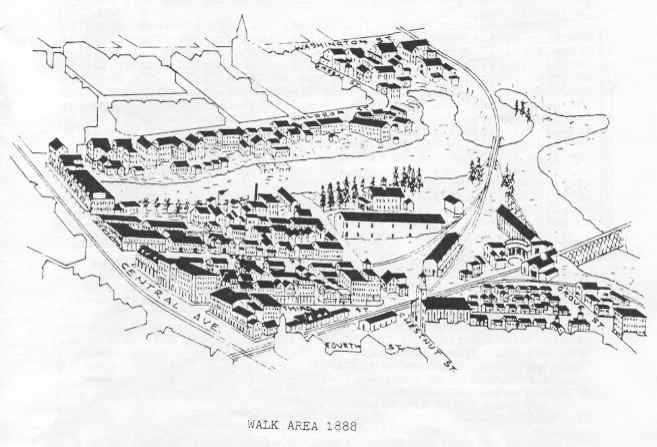
The 6th Annual Heritage Walk this year centers on the neighborhood bordered by Third Street, Central Avenue, the Cocheco River and Chestnut street.
This downtown area, spurred by urban renewal projects, private renovations, and commercial progress, has changed its face often in its long history: from the site of Dover’s first industry, Waldron’s sawmill, in 1642, to a boarding-house neighborhood during the heyday of the Cocheco Manufacturing Company, to a thriving business district now in the process of gentrification.
Many of the historic sites and buildings along this year’s walk are no longer visible because of all the changes in the area of Dover, but history has recorded their presence.
Waldron Towers / Riverview /Cocheco Park
These apartment complexes, mainly housing for the elderly, were constructed between 1976 and 1980. A massive downtown urban renewal project razed several buildings and homes in the area and even redesigned old streets, moving Green Street and eliminating much of Waldron Street. The Orchard Street parking lot was completed in the Fall of 1977 and the walkway along the Cocheco River was finished in Spring, 1978. The Trela and O’Neil Houses, built ca. 1827 -30 as boarding houses for mill workers, were restored in June, 1980. The Chestnut Street Bridge (“Memorial Bridge”), the first to cross the Cocheco at that at that point on the river, opened to traffic July 10, 1975, and the Eastern States Warehouse on the site of Shop ‘N Save was the last of the old buildings to be demolished in March, 1976.
The Cocheco River
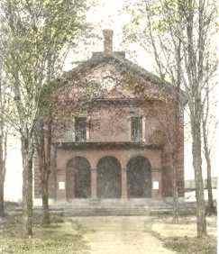
Indian for “swift, foaming water”, the Cocheco determined much of the course of Dover’s history. The river’s headwaters start in New Durham and meander 33 miles, including nine falls, to join the Piscataqua River on the way to the Atlantic. Dover’s first industry, Major Richard Waldron’s (Walderne) sawmill at the lower fall’s, was begun in 1642 and probably accounted for the village’s first settlers . Later, in the 17th and 18th centuries, boat building, fish exporting, and brickyards were developed. The 19th century saw the use of water power from the river to run the wheels of the cotton mills and calico printery. In the early 20th century ice houses dotted these banks in winter and boats-to-let flourished in summer. Industrial waste polluted much of the river in the past 75 years, but since the 1960 construction of the sewage treatment plant the Cocheco River has been on the comeback trail and a hydropower plant has recently come on line at the falls.
Central Street (Until 1886) / Central Avenue
Always the main access route through Dover village, Central Avenue has also always been a commercial district. By studying the variety of 19th century businesses that have occupied these stores, it is possible to observe the growth and sophistication of Dover.
The 1820’s and ‘30’s saw stores offering only basic supplies: food, fabrics, shoemakers. During the 1840’s hatmakers were in vogue and exotic East & West India goods imported from Barbadoes were available. By the 1850’s, varied types of groceries and confections were offered, as were “refreshment saloons”. The 1860’s were characterized by the addition of photographers, portrait artists, and hairdressers to the Dover scene as the city began to “gussy up”. The 1870’s saw the separation of clothing stores, now with “finished goods”, into those stores for men and those for women. The 1880’s moved professionals into downtown as dentists, doctors, lawyers, and insurance agents opened offices in the upstairs floors of the new “Blocks” built along the Avenue. By the 1890’s all the niceties of life had arrived: jewelers, upholsters, and wallpapers, stationers, and booksellers, pharmacies, clothes cleaners, musical instrument dealers, rug sellers, real estate agents, opticians, cigar and ice cream stores, and even architects had established businesses here. By 1900, the variety of goods and services offered was as wide as those offered today.
Central Avenue Bridges
Six bridges have spanned the Cocheco River Since the 1640’s when people crossed on a “boom” of logs. The first bridge, ca. 1762, was made of “Pitch Pine Piers” and washed away in the Greatest Freshet of 1785. The Cocheco Manufacturing Company built the second bridge in 1824. In 1845, this “Factory Bridge” was widened and had several stone pillars added. The fourth bridge, made of iron, was built in 1876 for $20,000, the fifth in1913 for 45,000, and the sixth (and present) opened on September 30, 1976. In all its history, there has never been a toll on the Central Avenue Bridge.
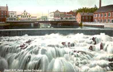
Bracwell Building/ 422-434 Central Avenue
The original block was constructed in1877-79 by Colonel John Bracewell, a wealthy Print Works Supervisor. It cost $40,000, and extended over the Cocheco River on a span of granite piers. It housed eleven businesses. One-third of the block was lost, however, in the famous flood of March 1, 1896, “Dover’s Black Day”.
A severe storm had caused the river to rise ten feet above normal and when loose ice chunks hit the piers the Central Avenue Bridge and three stores at the end of the Bracewell Building fell into the river tearing down most of the power lines for the Avenue as well. Dover lost three bridges that day and total losses from the storm were estimated at $300,000.
First Street
Originally called Front Street had only one house belonging to Mathew Bridge, Esquire, at the west end which culminated in a beautiful grove and picnic area near the river. By the 1830’s, the street was populated by the mill workers living in numerous boarding houses. Most of the home on First Street were not built on site but moved to their present locations from nearby area’s of town. Some were relocated when the railroad came to Dover in 1842, others when the commercial “Blocks” on Central Avenue were constructed between 1844-84. The small house at 35 First Street is said to have come up from Portsmouth on a Barge. These resettlements may account for the fact that many of the houses on this street seem not to face the correct way.
While the north side of the First Street had always remained residential, the south side on the banks of the river has housed C. H. Trickey’s Coal and Wood Office (1872), Dover’s first Telephone Exchange (1881), the Lincoln Hook and Ladder Company (1880), and a day care center for the children of Pacific Mills’ female employees (1921).
Second Street
This street was constructed in 1822 and originally extended all the way across Chestnut to back (now Grove) Street. It was a fashionable neighborhood and housed many prominent citizens.
35 Second (Silverman & Penna):
Built ca. 1830 by blacksmith Bradley Osgood, this house remained in the same family until heirs sold it in 1919 to the National Civic Federation’s Local chapter.
On August 1919, it reopened as the Dover Neighborhood House whose object was “the cooperation of the American and foreign- born to discover by education, recreation, and friendships, the finest things of which our civilization is capable.”
Between 200-500 children were attracted by its playgrounds, skits, classes, plays, and games. Women were given instruction in cooking, knitting, sewing, first aid, and English. Volunteers operated a 40 child kindergarten and a Well-Baby Clinic.
A 1926 restoration uncovered second-floor wall murals done by an unknown itinerant artist depicting Dover Point scenes of long ago. Sadly, these American folk art creations were obliterated beyond repair by a later tenant.
The Dover Neighborhood House was a great success, attracting regional and national attention for its Americanization programs and it remained active in the community until at least 1942.
31 Second (white w/blue trim; red roof):
Originally the home of Dr. Payne, a homeopathic physician, and after 1871, the home of Dr. Pike, a surgeon.
32-34 Second (tan w/brown shutters):
This house occupied by Samuel C. Hayes, was moved here from the site of the Country Courthouse when that structure was built in 1890.
28-30 Second (white w/blue trim):
Home of G. H. Preston
23 Second (dark brown):
Home of Thomas B. Garland, first librarian, Clerk of the Print Works, Treasurer of the Dover Gaslight Company, and President of the Dover Navigation Company.
24-26 Second (cream w/black shutters) and 22 Second (lt. green):
Both of these houses were owned by Dr. Paul Stackpole, who died in 1900. He owned all the land down to First Street and caused a ruckus in Dover when he cut down a 300-year old oak tree in order to build a stable.
18-20 Second (brown):
Home of William Wiggin, Director of the Cocheco Bank and a well known civil engineer.
17-19 Second (Woods Flooring):
Home of Dr. Alonzo Quint, D.D., a clergyman and historian. He authored Historical Memoranda of Ancient Dover and wrote a column for the Dover Enquirer newspaper.
14-16 Second (gray):
Always a two-owner home, this house was originally occupied by Dr. G. Dunn and J. Anderton. It is the most architecturally significant house on Second Street with stained glass panels in its windows, iron filigree on the roof, two gables, two gargoyles over the front doors, and in the backyard, the remains of two fountains. Between this house and Wiggin’s was a small alley that connected to First Street.
11 Second (yellow):
Originally two homes stood here, one belonging to Mrs. W. Morrill and the other to the Anderton family. Both were razed when this tenement was built.
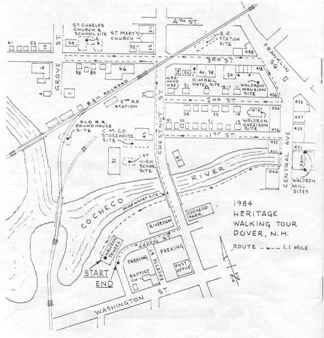
6-10 Second/Strafford County Courthouse
Following the city hall fire of 1889, county officials built this brick courthouse, completed in the Spring of 1890, for $30,000. Houses on this site were moved to new locations on First and Second Streets or torn down. The Courthouse featured offices for all county officials and judges, and a 300-seat courtroom on the Second floor.
An annex was built in 1947-48 and some problems with quicksand were encountered during this construction. This facility was used until 1974 when the new Justice & administration Building was completed. It is now privately owned.
Waldron Garrison
On the site of the courthouse, Major Richard Waldron built his home “in the style of the best houses in Boston” in 1664. It was “garrisoned” by adding a stockade fence in 1674. During the Indian troubles in the Seacoast, it served as then center of military activity in the region. On the night of June 28, 1689, in revenge for past injustices, the Indians attacked, burned the garrison and killed the 80-year old Major. Similar scenes occurred at six other Dover garrisons that night with 23 people killed and 29 taken captive.
Waldron Mansion
Directly across Second Street from the garrison site, Colonel Thomas Westbrook Waldron, great-grandson of Major Richard, built his home in 1763. It was “a stately mansion with oddly carved wooden dining room, handsome old mahogany furniture, and great paintings on high-posted walls.” It originally faced Franklin Square and had a garden running to the river and an orchard with a natural spring. It was moved around to face Second Street ca. 1844 when Joseph Morrill built his Block on Central Street and was turned into tenements.
The National Block, 436-454 Central Avenue
Located between First and Second Streets, this block was erected in the early 1800’s. Some of the businesses located here included:
436-438…Dover Clothing Co., retailers of Sawyer Woolens
444…….Charles Hodgdon’s jewelry store (later Kate’s Style shop)
450…….Whitehouse Opticians (now on Broadway)
452-454…Dearborn Dry Goods, largest in Dover
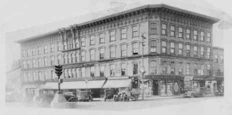
The Morrill Block, 456-466 Central Avenue
Joseph Morrill (1796-1871) bought this land at the corner of Second Street from the Cocheco Manufacturing Company, turned the Waldron mansion around and moved it back on Second Street. He built a three story block in 1844.
Franklin Square
The 1827 map of Dover designates the junction of Main Street and Central Street as Franklin Square. Over the years, the area became known as Upper Square, but in 1981, after the square was revitalized and refurbished, it was rechristened Franklin Square. The granite fountain and horse trough, a gift to the city ca. 1914 by the heirs of Joseph Morrill, was reconditioned and reinstalled.
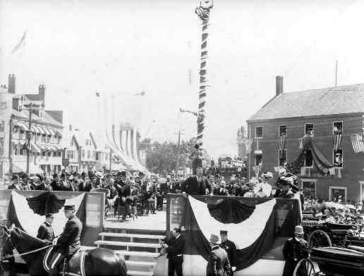
Many events have taken place in the square. Two of the most notable were the receptions for two U.S. Presidents: Teddy Roosevelt in 1902 and William Howard Taft In 1912.
Merchants National Bank, 488 Central Avenue
By 1850, a string of buildings had been built along Central Avenue from the corner of Third Street all the way to the railroad tracks. These housed several businesses and the 1851 map labels it “R.R. Block”. In this same year, the Cocheco Bank was incorporated here. In 1865, the Cocheco National Bank was begun and the Cocheco Savings Bank in 1872. They occupied this corner of Third Street until 1900 when the Merchants National Bank was founded.
In 1910, Merchants purchased three buildings on the corner for expansion purposes and have been here ever since. The Merchants Savings Bank was also here from 1901 to 1974, when they built the new building further up Central Avenue that is now renamed Seacost Savings Bank.
Third Street
This street originally had only four houses, used as boarding houses by mill workers. The north side of the Street was completely taken up by the Cocheco Manufacturing Company’s woodyard from 1821-42. The yard, bordered by a high stockade fence, had its entrance on Central Street and ran all the way to Chestnut. The wood was kept covered under long sheds and Franklin Square would be crowded with teams of horses and their loads. The boss of the woodyard would make offers for the different loads ($2-$4 per cord).
When the mills began using coal ca. 1840, the need for wood diminished; when the B&M railroad came to Dover in 1842, the yard was closed to make room for tracks, stations, and trains.
The arrival of the railroad in Dover shaped the development of Third Street to a large extent. Most businesses were dependent on railroad clientele for their survival. Hotels, theaters, saloons, and restaurants lined the South side of the street over the years.
The railroad station was built in 1842 on the site where the municipal parking lot is now. Soon the railroad added a roundhouse and engine facilities near the Cocheco River and two branch lines: Cocheco Railroad to Alton Bay (1851), and the Portsmouth & Dover Railroad (1874). There were nine stations in within Dover’s boundaries and it moved the focus of Dover’s business from the landing, which was dependent on shipping, to the Third Street rail lines.
In 1928, Dover became headquarters for the Portland division of the B&M. the two-story station was modified to three and a new round house (still existing) was built further east near Oak Street.
456…Spofford-Allis Clothing Co., Dover’s first chain store
462…The Sugar Bowl (now Rivers’)
463…Clark & Aldrich secondhand store
464…a hall used by Pythians, Oddfellows, Redman, various Dover bands
466…Lothrop and Pinkham’s Pharmacy (through the 1940’s)
The “New” Morrill Block, 468-484 Central Avenue
Also built by Joseph Morrill, this structure was a four-story wooden building constructed between 1870-74. Its more famous occupants included:
474…………D. Lothrop & Co., pianos, organs & sewing machines
476-480…….Lothrop’s & Farnham’s
Cor. Central & Third ….Boston Branch Grocery; Daeris’ Tea Room
A fire January 3, 1932 razed the building and wiped out 26 businesses. One of Dover’s most devastating and spectacular fires, the blaze required fireman from as far way as Haverill, Mass., and burned so hotly that the sprinkler system is the Strand Theater was set off. The current two-story Morrill Building was rebuilt shortly thereafter.
Morrill Block
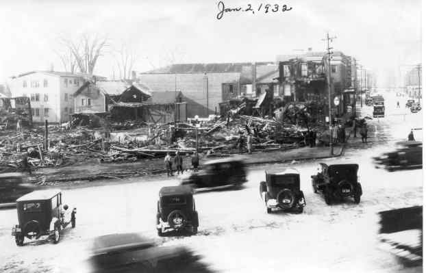
Morrill Block after the fire
Gradually passenger service declined; the last passenger train left Dover in 1967. Eventually the station was torn down to make the parking lot and a smaller station built further west of Chestnut Street.
South Side, Third Street
Influenced by the presence of the railroad, the businesses on Third Street consisted mainly of hotels, restaurants, and saloons; but it also had its share of furniture stores and some shoe manufacturers.
In addition to the American House, the most prominent hotel on Franklin Square, there were at various times four or five hotels on Third Street. Near the Square were the Franklin House and the City Hotel. The U.S. Hotel was on the site of the Strand Theater for about 40 years before the theater was built ca. 1920. The New Hampshire Hotel (ca.1892), Evans House (1898), the Anderson (1902), and the Lenox (1905) took turns on the site where Elias Anton had a furniture store (ca. 1928-41) before Ross Furniture occupied the site.. The Kimball Hotel lasted the longest, starting in 1870 and continuing until early 1982 when a fire demolished it along with the Asia Restaurant which has since been rebuilt.
Between the New Hampshire and the Kimball was a building which started out as the Universalist Church in 1837. It continued until 1875, when it was sold to former mayor George Lowell who added a brick front and remodeled the interior. The Universalists built, in 1882, the Peirce Memorial Church formerly on Central Avenue. Lowell’s Crockery Shop occupied the site until the Lyric Theater took over from ca. 1909 and lasted until the 1930’s.
Near the corner of Third and Chestnut was a large building that housed furniture stores. Dover Furniture (mid-1890’sto1920), E. Morrill Furniture (founded in 1840 at 95 Washington St.) from 1920 to 1940, Greenlaw to 1948, and finally, Warren’s which burned in 197
On the opposite corner, a large building was occupied by shoe manufacturers during the 1860’s-1880’s. Later, the J.M. Wilson Co., beef and provisions, were here and they had a wire running across Chestnut Street high above the traffic. Sides of beef that came in on the railroad were transferred to the building by pulling them across Chestnut Street on this wire.
St. Mary’s Church
The Irish immigrants who had arrived in Dover to work in the mills desired their own Catholic Church, so the Cocheco Manufacturing Company donated land at the corner of Third and Chestnut. A wooden, gothic church was built in 1830 and the parish was named St. Aloysius. A two-wing addition was put on in 1839 as the parish expanded. In 1870, the old church was moved back on the lot and a new brick building started in front. A fire on Halloween burned the old church and a lot of the new structure. Eventually construction resumed and the present brick church was completed in 1872 and renamed St. Mary’s. The rectory at the rear was built in 1875 and later remodeled. In 1947, the Diamond Jubilee Anniversary of the parish, the heavy cornice and crosses on the tower were removed and replaced with a new roof and a single cross. St. Mary’s celebrated its 150th anniversary in 1980.
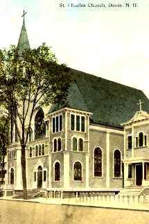
St. Charles Church/ St. Charles School
The vacant area beyond St. Mary’s was the site of the original St. Charles Roman Catholic Church and School. As French-Canadians arrived in Dover during the 1880’s, they formed a separate parish from the “Irish Church”. In 1896, a church was built here for $12,000. The rectory was located where the Dover Senior Center is now. In 1901, a two-story school was built adjacent to the church and in 1914 a larger school, costing $20,000 and housing 40 pupils was built. Both of these structures were eventually destroyed by fires, the Church on January 24, 1932 (only three weeks after the Morrill Block Fire), and the school in 1968. In 1933, the new St. Charles Church was built on Central Avenue and continues there today.
M & M Bakery, 66 Third Street
The M & M started before World War I at 398 Central Avenue. In 1927, the owners constructed this building which housed the bread department on the first floor, the cake department on the second, and the dough room on the third. Over 100 trucks delivered these products throughout New England. The bakery closed about 1961.
6 Grove Street
This large building on the southwest corner of Grove and Third is often called the Judson Dunaway Building. Mr. Dunaway, Dover’s greatest philanthropist, came here in 1928 and found the Expello Corporation at 15 Fourth Street. About 1940, they moved to this building with their two main products: Expello (moth repellent) and Vanish (toilet bowl cleaner). In 1945, the name was changed to the Judson Dunaway Corp., which continued in Dover until 1958 when it was sold to the Drackett Co. Since then, the building had served as a warehouse, and since1965, the home of Northern Heel.
10 Grove Street
This fourth-story wooden building was a shoe factory until ca. 1930. Built about 1868 by T.J. Canney, it was leased to John H. Hurd. Later occupants were Leighton & Drew, Bradley & Sayward, O.A. Gibbs, and L.M. Block and Son. For a few years in the 1960’s it was a warehouse, but it is now boarded up.
Chestnut Street
One of the original streets making up Dover Village, Chestnut Street ran from brick (now Sixth Street) to the Cocheco River. There was no bridge here until 1975. The west side of Chestnut was a lush, tree-lined gore where early Doverites held picnics, celebrations and parades. The banks down to the river were sites of family outings and community functions. First and Second Streets originally bisected it and ran all the way to Grove Street.
“The Sham Battle”
In September 1676, Major Richard Waldron arranged with the 400 Indians at Cocheco (200 of whom were refugees from the Massachuteses Indian Wars) to stage a mock fight between the Indians and the local militia. The Indians agreed, but during the sham battle, the Native Americans were seized for real after being easily surrounded. The Northern Indians were released but the Southern refugees were taken into slavery. The local Indians never forgave Waldron for his part in the deception, and took their revenge thirteen years later when the Dover garrisons were burned and the Major murdered.
Tradition claims that this sham fight took place on the site of the present shop ‘N Save.
The High School
On the site of the “Sham Battle” in the midst of the beautiful grove Dover’s first high school was built in 1851. Land was purchased from the Cocheco Manufacturing Company for $600 and the building erected for $15,000. A three-year course of study was instituted, but only students from the north side of the river were allowed to attend. In 1869, the Dover School system was consolidated, the inequities remedied, and all Dover students welcomed. By this time, 80 students were in attendance. In 1873-74, the great grove of trees behind the school was cut down to make room for the railroad expansion, and the beautiful west end of Chestnut Street was in decline. By 1904, the building was considered “poor in location and in equipment” and a new facility was built on Locust Street (now DJHS). The building on Chestnut Street reverted back to the mill owners in 1907, who tore down the old school to erect the warehouse that was eventually, torn down in March, 1976, when it was known as the Eastern States Warehouse. The present supermarket complex opened in October, 1978.
Cocheco Storehouse
After the development of the railroad into Dover, the Cocheco Manufacturing Company built a 324’ x 156’ warehouse on a site between shop ’N Save and the present Moose Hall. Freight cars could run directly into it and there was a coal pocket between the store house and the river. Cars from the coal fields could be driven onto a track immediately over the coal pocket and drop their load. Coal would then be hauled to the boiler house at the mills by two horse dump carts.